
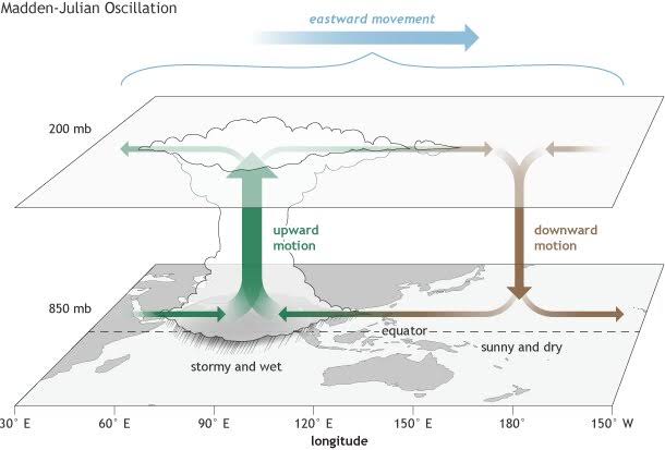
An atmospheric phenomenon which travels eastward over the warm waters of the Indian and Pacific oceans results in anomalous rainfall pattern over the Indian subcontinent. This phenomenon is known as the Madden-Julian Oscillation. Unlike El-Nino southern oscillation or the Indian Ocean dipole, this is a travelling atmospheric phenomenon. In this oscillation, there is coupling on a wide scale between the deep atmospheric convection and atmospheric circulation which results an eastward movement of both the suppressed and enhanced tropical rainfall clouds. This phenomenon is actually a body of rain clouds over tropical waters which moves eastward over an extent of 12000 to 20000 km. It is known as oscillation since there are intermittent periods of cyclonic activities interspaced by lull periods.
As a result of increasing atmospheric concentrations of the greenhouse gases, the global average temperature is rising for both the atmosphere and the oceans. The fast warming region of the Indo-Pacific Ocean is probably responsible for the changing and anomalous patterns of rainfall across many regions of the globe including over the Indian subcontinent. The phenomenon of the Madden Julian oscillation is one of the main causative agents for the changing rainfall pattern. The changes caused by the MJO phenomenon result in decline in the rainfall over east and west coasts of USA, central pacific, eastern Africa, the Yangtze basin in China, and in North India. Whereas the same MJO has caused increased rainfall over the west Pacific, northern Australia, Amazon basin, southeast Asia and southwest Africa.
Climate simulation models have suggested that the gradual warming of the Indo-Pacific Ocean is highly likely on a long term basis, which implies that the changes caused in the MJO pattern is only going to be strengthened. This means that the reduced rainfall over north India is increasingly probable in the coming years. Changes in the MJO pattern due to warming up of Indo-Pacific Ocean affect the rainfall over north India in the November to April. As a result of the reduced rainfall in that season, the Rabi crops harvest would be impacted. The numerous factors involved in the amount of rainfall over the Indian subcontinent affect the mean and extreme rainfall. There are other factors and phenomena which affect the Indian rainfall which include the Western Disturbance, the Indian Ocean Dipole, and the Tropical Easterly Jet. This makes the prediction of the rainfall pattern over India complex. In this context, using the climate simulation models is crucial to a better understanding the rainfall in a warming up world.
To get a clearer picture of the rainfall, inputs relevant for the Madden-Julian Oscillation need to be fed in climate models to better grasp the impact of the oscillation over Indian rainfall. The area of the warming up region and the rate of increase of the warming of the Indo Pacific Ocean make the effect of the MJO over rainfall two fold. The warmest waters in this particular region are in the west Pacific which creates a humidity gradient which causes the movement of moisture from the Indian Ocean to that region. This drives the cloud formation over the west Pacific region. Warmer oceans have driven a change in the life cycle of the rain cloud formation over the warm tropical ocean waters. As the oceans are getting warmer, the rain clouds in the MJO band are getting a shorter residence-time over the Indian Ocean waters by around four days. This has resulted their residence time over the Indian Ocean to become 15 days instead of the normal 19 days. As a result the clouds are staying longer over the west Pacific region. The arrival of the MJO cloud pattern over India in the period of June to September can cause increase in the rainfall.
There are evidences that the MJO and the El Nino southern Oscillation are correlated to one another. The crucial difference between the two is that the El Nino is an inter-annual oscillation and a stationary phenomenon and the Madden Julian oscillation is an intra-seasonal moving oscillation. Studies on the climate simulation models developed by the Australian Bureau of Meteorology had predicted that MJO would form and get stronger near the West Indian Ocean and the east African region and would move eastward. It had been suggested that this pattern would bring higher than normal rainfall in India. Recently the Australian Bureau of Meteorology had also raised a La Nina alert over the pacific. The La Nina has been known to bring higher than normal rainfall in most parts of India. This along with the arrival of Madden Julian oscillation in the period of June to September is probably the cause of the rainfall (this year) being way above the normal level in various parts of India.
To predict the occurrences of floods (like in the current year) a clearer understanding of such phenomena like the Madden Julian oscillation, El Nino southern Oscillation, Indian Ocean Dipole is required. In this regard, the sharing of the weather data with the international weather and climate agencies and research bodies is essential. Madden Julian oscillation forms an important aspect in the complete story of the prediction of Indian monsoon and the amount of the rainfall. It is more relevant in a world where the oceans are undeniably getting warmer, the largest body of which is in the Indo-Pacific region. Since, rainfall is intertwined with the traditional format of Indian agriculture which is the base of food security, knowledge of MJO and its prediction become inevitably obligatory.