
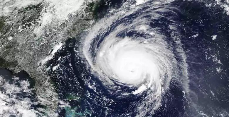
Cyclones are storm systems where air flows towards a low-pressure centre known as the eye of the storm, which generally pulls air laden with moisture, thereby bringing in precipitation or rain. Such storms move so as to balance out the pressure. The cyclonic storms in the northern hemisphere rotate in counter clockwise direction and those in the southern hemisphere do so in the clockwise direction due to Coriolis force caused by earth’s rotation. The anticyclones are caused by a high-pressure system which gives clear weather where air flows away from a high pressure centre. Anticyclones rotate clockwise in the northern hemisphere and anticlockwise in the southern hemisphere.
Here, the discussion will be focused on the cyclonic systems, especially with respect to Indian Ocean region spread from Arabian Sea to Bay Bengal region. Cyclones are storms formed over sea bodies in tropical region between the Tropics of cancer and Capricorn, when specific conditions are fulfilled. The conditions which are conducive to formation of cyclones are as listed here
- A wide area of sea surface having a temperature above 27 degrees Celsius
- Coriolis force strong enough to create a cyclonic vortex
- A pre-existing low-level cyclonic circulation or weak low pressure region which helps in formation of a depression
- An upper divergence above sea level in an Inter-Tropical Convergence Zone (ITCZ) region where two masses of air with different temperatures meet creating an instability
- Presence of small variations in the vertical wind speed
Also Read: Impact of the Madden Julian Oscillation on the rainfall over Indian subcontinent
The stages through which a cyclone develops are depression, deep depression, cyclonic storm, severe cyclonic storm, very severe cyclonic storm, extremely severe cyclonic storm, and Super cyclonic storm as classified by the Indian Meteorological department.
The waters of Bay of Bengal are warmer with respect to the waters of the Arabian Sea. This makes Bay of Bengal more prone to cyclone-formation with respect to the Arabian Sea. All factors considered there are some differences and similarities among the cyclones which have impacted the east and west coasts of India. As per trends over decades, the West Indian Ocean including the Arabian Sea region has experienced fewer cyclones than the Bay of Bengal region or the East Indian Ocean. The West coast of India has been pounded by 48 tropical cyclones between the years 1891 and 2000. Twenty-four out of these 48 were severe cyclonic storms. The East Indian coast, on the other hand has been impacted by 308 cyclones, which included 103 severe cyclonic storms. From 2014 to 2019, there has been a 32 % rise in the number of cyclonic storms, which has been consistent with the overall rising temperatures of the Indian Ocean.
Formation of depression & heat redistribution
As the humid air rises, due to adiabatic expansion, the temperature of the air falls (adiabatic lapse rate). That leads to condensation of the moisture in the air, which releases the latent heat of condensation which makes the air hotter. That leads to further uplift of the air, which allows more hot air to fill the lower sections near the sea surface. This loads more moisture into the air from the sea, triggering a fresh cycle of rise of humid air.
In the sea, the redistribution of heat occurs in two ways, across the latitudes and across the depths. For the formation of cyclone, the moisture needs to be fed into the rising columns of warm air over the ocean waters in the tropical region, through an instability created in ITCZ region.
With this requirement, the Bay of Bengal provides a cradle for formation of more frequent storms with respect to the Arabian Sea.
Feature of Bay of Bengal
In the Bay of Bengal, large voluminous rivers like Ganga, Godavari and Brahmaputra empty out their waters. On top of it, the Bay has a larger number of river mouths. This leads to larger volumes of water to be added into the Bay of Bengal, which feeds continuously warm waters over the surface of the Sea. That leads to the maintenance of supply for warm waters which can feed the rising warm air as moisture. Due to this, the preponderance of cyclone formation is higher over Bay of Bengal than over Arabian Sea. Additionally, a warmer Bay of Bengal due to climate change leads to faster intensification of the cyclone through various stages from Depression towards severe cyclone stages.
Also Read: Can Indian Ocean Dipole alone help us understand the Indian monsoon?
The Deep Depression formed over East-central Bay of Bengal remained practically stationary for 6 hours. Then it intensified into Cyclonic Storm ‘Yaas’ moving slowly north-northwestwards. Amphan, which was a category 5 cyclone had hit the east coast last year, when India was in the clutches of the first wave of Covid19, causing damages worth $13 billion. It was the costliest cyclone ever to brew in the north Indian Ocean breaking the previously held record by Cyclone Nargis, which had hit in 2008.
The rapid intensification of last year’s Cyclone Amphan, from a cyclone to a super cyclone in about 40 hours, was pegged to be a sign of a warming Bay of Bengal, which was noted to be a consequence of global warming, as opined by experts. With the course of development of Cyclone Yaas, the process over the oceans repeated itself. As the storm moved in, the sea surface temperature (SST) of very warm Bay of Bengal, between 30 to 31 degrees Celsius was one of the main factors that quickly intensified the storm.
In the case of Cyclone Taukte, which had made landfall at Saurashtra coast, the rate at which its intensity decreased was lower than expected. IMD had predicted that before landfall, Tauktae would decrease in intensity from an extremely severe cyclone (166-220 kmph wind speeds) to a very severe cyclone (118-165 kmph). But the cyclone remained an extremely severe cyclone with wind speeds of upto 170 kmph and occasional gusts of up to 185 kmph, as per observations made by IMD. Experts opined that such an event happening on the Gujarat coast is very rare.
Cyclone Tauktae is unique in the sense that it had followed the trend of unusual and unpredictable cyclones since cyclone Ockhi in 2017. It underwent rapid intensification, making it difficult to forecast its severity. The cyclone intensified from a depression to severe cyclone in two days which is a new record, as previously, cyclones took four-five days in this intensification process.
The faster rates of intensification of cyclones over both Bay of Bengal and Arabian Sea indicate that the warming up seas are indeed playing a role in worsening cyclone situations over both east and west coasts. This would pose larger challenges in the coming years in cities like Mumbai and Kolkata, with regards like flooding and possible claiming of the city-areas by seas.